|
|
|
The Localligence Spatial
Platform (LSP) is a server comprised of a number of modules that
perform specific roles in spatially enabling an enterprise's
data. This server can reside locally behind the firewall
within an intranet environment, or be remotely
hosted at the Localligence data center for internet based
applications. What option an enterprise
selects is generally based on the type of data and
application under consideration and the level of security
required.
|
|
|
|
|
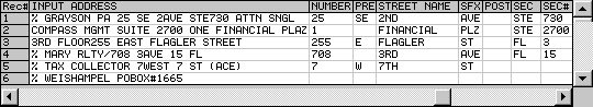
Address
cleansing is a critical component of the Localligence
Spatial Platform (LSP) as it ensures that addresses are valid and
can therefore be displayed visually on a map. As is often
the case in large enterprises, many addresses that are
captured are incomplete and missing critical identifying
features such as zip codes, address numbers or cities. It is
very important that addresses undergo "cleansing" to ensure
the quality of the data and to identify any possible data
entry problems or anomalies.
To help
cleanse addresses, the LSP has a
country specific address engine that compares every address
in an enterprise's database to a list of all known addresses
in the United States - 57 million plus! (Foreign addresses
are handled by a separate country engine.) The address
cleansing engine corrects
any mis-spellings and can reconstruct an address that is
missing key information, such as a city and/or zip. Below
are just some examples of addresses that have been cleansed
via the LSP.
Illustration:
Cleansing and correcting addresses

|
| |
|
|
|
|
|
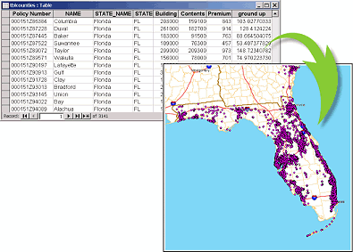
Geocoding is
the process of taking a location of a cleansed address and then placing
that correctly on a map. This is done by generating the
latitude and longitude coordinates of the location. These
two coordinates are then stored back, where applicable, with the original
address so that it doesn't have to undergo a repeat process.
The LSP geocoding engine can accurately position
addresses to a specific position along a street, or to a
defined area, such as a zip code or county. The
example below shows the geocoding process where an address
is assigned a latitude and longitude and then positioned on
a map.
Illustration:
Converting addresses to
coordinates on a map
|
| |
|
|
|
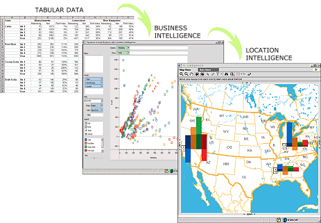
One of the many benefits
of a location intelligent solution is the enhanced
intuitiveness and ease-of-use provided by the data
visualization capabilities inherent in a map-based
application. These capabilities take
the best characteristics found in existing data
visualization tools, such as charts, graphs and
gauges and presents them in a spatial context;
providing greater clarity in understanding data and
there relationships to each other. Another key value that spatial visualization
provides is the ability to drill down and query data
using graphical tools as opposed to text-based query
commands. For example, if a manager were to look at
a map and identify an area of interest, such as poor
sales in a region, they simply need to zoom into
that area which automatically runs a query,
displaying the appropriate data based on it's geographic
context.
This ease-of-use frees up the power of information
and makes it readily available to a much wider
audience across an organization or enterprise -
empowering people to make better, faster and more
informed decisions .
Illustration: This example shows how location
intelligence can take complex multi-dimensional data and
then display it in a intuitive manner that leads to greater
clarity and understanding, resulting in
better, faster and more informed decision making.
|
| |
|
|
|
|
|
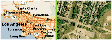
Central to
any spatial application is the ability to be able to quickly
and efficiently deliver maps to the client application. The
Localligence Spatial Platform has been optimized to perform
this task utilizing a combination of both vector and raster
data. Vector data provides the fastest map display, but is
not as rich as raster data which can contain satellite and
aerial photography of an area. Customers can choose to have
one or both types of maps, and also have control over how
the maps are drawn and the colors used. For example, some
customers may prefer their roads in orange, while others blue. Some may only require to see major highways, whereas
others may want to see detailed streets and lanes.
Illustration: An
example of vector map data (left) and raster (right)
|
| |
|
|
|
|
|
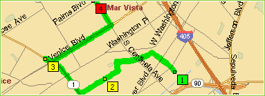
The Routing
engine in the Localligence Spatial Platform is used to
determine driving directions between various locations,
providing step-by-step instructions along the way. A user
enters their starting location followed by either an
ending location or various stops that need to be made along
the way. Once entered, the Routing engine then displays the
optimized route to take.
Illustration: An
example of driving directions featuring multiple stops
|
| |
|