CPG (Consumer
Packaged Goods)
retailers are faced with enormous amounts of data
that needs to be compiled, understood and made
actionable. For these companies nearly all of this
data has a location component, be it the address of
a warehouse, the location of a store or even the
position of a product sitting on a shelf. With
location being such an important element to retail
data, it makes sense to utilize the power of
location to quickly and easily spot trends, identify
problem areas and more product efficiently and
effectively thorough the entire supply chain, from
point of distribution to point of sale. The
following scenarios provide a more detailed look
into how location can be used to help managers make
better, faster and more informed decisions:
|
|
|
|
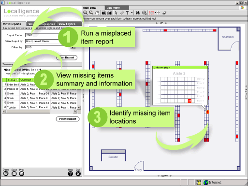
Recent advances in item level tracking such as RFID
(Radio Frequency ID) are giving retailers greater
insight into how product moves off shelves. For
example, a store can track misplaced items as well
as identify where the "hot" and "cold" areas of the
store are. Being inundated with such large amounts
of new data can be difficult to manage yet alone
visualize. However, by using the power of location,
retailers can easily "see" where inside their stores
product is moving and how best to ensure that
inventories are maintained, that items are correctly
positioned and that the "hottest" areas have the
"hottest" products. The following sample application
is an example of how location-based
visualization can help identify misplaced items
within a store, making it easier for store
associates to ensure that product is positioned
correctly and that the right product is always
visible and available.
Click to zoom in
 |
|
|
|
|
|
|
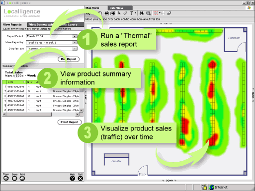
One
of the most important jobs for any store manager is
understanding where to place product in relation to
traffic flow. This is particularly important when
promoting specific product or trying to push product
that is fast approaching it's shelf life. By using
location intelligence, a company can track product
sold and then identify spatially on a map hw that
product performed based on its location. For
example, in the following sample application a
"thermal" map has been created which identifies the
"hot and "cold" areas of a store. These areas are
identified by tracking the time product was sold and
then placing the product within a store floor plan
(map).
Click to zoom in
|
|
|
|
|
|
|
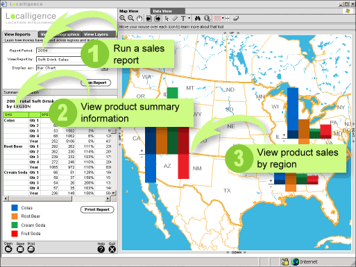
Every
day retail managers pour over sales figures to get a
feel for how well their business is doing. Location
intelligent maps can provide a fast and intuitive
way to understand the health of their business by
easily presenting data from a regional view right
down to a store view. In the following example a
manager is able to quickly and easily identify how
well soft drinks are selling nationwide by region.
By using Localligence mapping tools, the manager is
then able to zoom into a region and drill down
deeper, to the state, county, zip code and even
store level to gain a better understand as to how
the numbers were generated.
Click to zoom in
|
|